Log in
All resources
Create a design
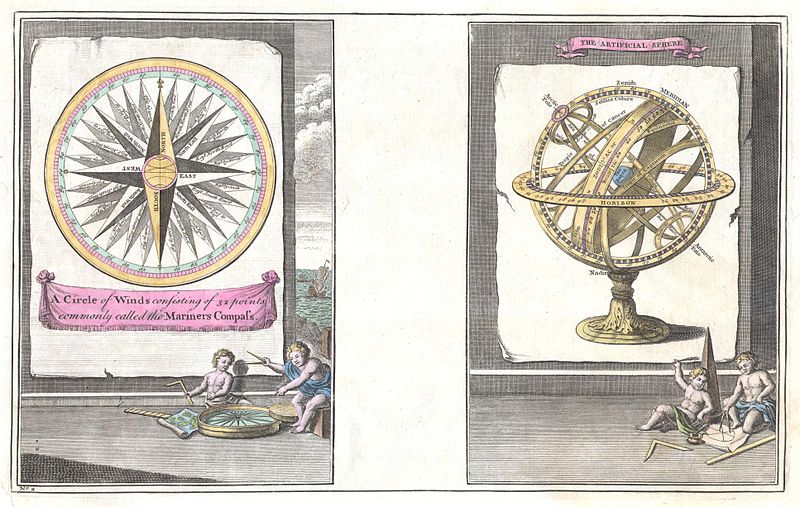
104 Free Artworks of Wind Rose
bibliothèque nationale de france
a map of the british empire in america with the french and spanish settlements adjacent thereto
maps by pieter van der keere
maps from gallica
maps with cartouches
maps by pieter mortier
stenen tafel
vintage
eerie
narrative
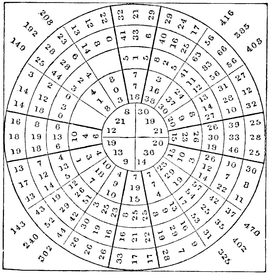
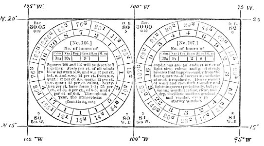
popular science monthly illustrations/volume 16
wind rose
popular science monthly illustrations/volume 16
wind rose
the antiquities of athens, vol. i ch. iii
greek revival architecture
paintings by guy rose
impressionism
nzow compass roses (dutch)
stenen tafel
vintage
eerie
vintage
ghost
drawings by dankvart dreyer in the statens museum for kunst
danish golden age
vintage
ghost
female
ghost
stenen tafel
stenen tafel
stenen tafel
1747 engravings
compass roses
1747 engravings
compass roses
hendrik van langren map of south asia
1600 maps of asia
a chronicle of england, b.c. 55 – a.d. 1485
battle of towton
1610s maps of the netherlands
old maps of friesland
maps of brazil by hendrik hondius
bibliothèque nationale de france
maps of brazil by hendrik hondius
bibliothèque nationale de france
maps by tomas lopez
1785 maps
bibliothèque nationale de france
maps by tomas lopez
arnold van langren map of southwest africa
1600 maps of africa
maps by pieter van der keere
old maps of flanders
maps by pieter van der keere
1600s maps of norway
philippe buache
wind roses
maps by willem and johannes blaeu
old maps of flanders
maps by pieter van der keere
maps with cartouches
the potter's wheel, 1906
lillie rose ernst
maps of provence by pierre-jean de bompar
maps by hendrik hondius the younger
maps by pieter van der keere
ships on maps
maps by pieter mortier
maps from gallica
bibliothèque nationale de france
guillaume sanson
arnold van langren map of east africa
1600 maps of africa
landkreis eichsfeld in the 17th century
maps from gallica
maps by pieter mortier
maps from gallica
maps by pieter van der keere
old maps of friesland
a map of the british empire in america with the french and spanish settlements adjacent thereto
bibliothèque nationale de france
a map of the british empire in america with the french and spanish settlements adjacent thereto
bibliothèque nationale de france
a map of the british empire in america with the french and spanish settlements adjacent thereto
bibliothèque nationale de france
maps of the land of valkenburg
guillaume sanson
a map of the british empire in america with the french and spanish settlements adjacent thereto
bibliothèque nationale de france
a map of the british empire in america with the french and spanish settlements adjacent thereto
bibliothèque nationale de france
a map of the british empire in america with the french and spanish settlements adjacent thereto
bibliothèque nationale de france
a map of the british empire in america with the french and spanish settlements adjacent thereto
bibliothèque nationale de france
a map of the british empire in america with the french and spanish settlements adjacent thereto
bibliothèque nationale de france
maps of the principality of erbach
maps by pieter van der keere
a map of the british empire in america with the french and spanish settlements adjacent thereto
bibliothèque nationale de france
a map of the british empire in america with the french and spanish settlements adjacent thereto
bibliothèque nationale de france
a map of the british empire in america with the french and spanish settlements adjacent thereto
bibliothèque nationale de france
a map of the british empire in america with the french and spanish settlements adjacent thereto
bibliothèque nationale de france
a map of the british empire in america with the french and spanish settlements adjacent thereto
bibliothèque nationale de france
a map of the british empire in america with the french and spanish settlements adjacent thereto
bibliothèque nationale de france
a map of the british empire in america with the french and spanish settlements adjacent thereto
bibliothèque nationale de france
a map of the british empire in america with the french and spanish settlements adjacent thereto
bibliothèque nationale de france
maps of rügen by eilhard lubinus
bibliothèque nationale de france
maps by willem and johannes blaeu
1638 maps of asia
context files from gallica
history of rügen
a map of the british empire in america with the french and spanish settlements adjacent thereto
1730s maps of the caribbean
a map of the british empire in america with the french and spanish settlements adjacent thereto
1730s maps of the caribbean
a map of the british empire in america with the french and spanish settlements adjacent thereto
1730s maps of central america
a map of the british empire in america with the french and spanish settlements adjacent thereto
1730s maps of the caribbean
wales in the 1600s
latin text
veteris novae que urbis amstelodamensis ichnographia, continens publica aedificia ; veterem subnigrioribus... delineata auctore d. stalpaert - btv1b53212660h
bibliothèque nationale de france
veteris novae que urbis amstelodamensis ichnographia, continens publica aedificia ; veterem subnigrioribus... delineata auctore d. stalpaert - btv1b53212660h
bibliothèque nationale de france
maps of the ganges river
old maps of bengal
1600 maps of africa
benjamin wright
maps by pieter mortier
maps from gallica
bibliothèque nationale de france
maps of wales by humphrey llwyd
1630s maps of the holy roman empire
maps by willem and johannes blaeu
maps of portugal by fernando álvares seco
bibliothèque nationale de france
context files from gallica
history of spain
charts and maps of the royal museums greenwich
1590 maps
bibliothèque nationale de france
maps of wales by humphrey llwyd
prints by james gillray in the british museum
satirical prints in the british museum
maps by pieter mortier
maps from gallica
bibliothèque nationale de france
joachim ottens
maps of the iberian peninsula by mercator-hondius
maps by pieter van der keere
william henry toms
henry popple
maps of wales by humphrey llwyd
maps by pieter van der keere
françois de la pointe
1620s maps of france
maps by jodocus hondius
maps by john speed
maps by pieter mortier
maps from gallica
maps of portugal by fernando álvares seco
bibliothèque nationale de france
maps by john rocque
wilton house
juan francisco leonardo (1687) mapa del arzobispado de toledo
1680s maps of spain
midle-sex described with the most famous cities of london and westminster (1610)
bibliothèque nationale de france
midle-sex described with the most famous cities of london and westminster (1610)
context files from gallica
the potter's wheel, 1907
caroline risque
a map of the british empire in america with the french and spanish settlements adjacent thereto
bibliothèque nationale de france
a map of the british empire in america with the french and spanish settlements adjacent thereto
bibliothèque nationale de france
a map of the british empire in america with the french and spanish settlements adjacent thereto
bibliothèque nationale de france
a map of the british empire in america with the french and spanish settlements adjacent thereto
bibliothèque nationale de france
a map of the british empire in america with the french and spanish settlements adjacent thereto
bibliothèque nationale de france
studies by frederic edwin church
hudson river school
a map of the british empire in america with the french and spanish settlements adjacent thereto
bibliothèque nationale de france
maps in the rijksmuseum amsterdam
old maps of the ottoman empire
chinese-language literature
jiangxi poetry school
maps of the iberian peninsula by mercator-hondius
maps by pieter van der keere
satirical prints in the british museum
carolus allard
1 - 100 of 104
Next page
/ 2


![Cambriae typus / Auctore Humfredo Lhuydo Denbigiense Cambrobritanno; Petrus Kaerius coela[vit], 1607](https://cdn.creazilla.com/illustrations/10001017812/cambriae-typus-auctore-humfredo-lhuydo-denbigiense-cambrobritanno-petrus-kaerius-coela-vit-1607-md.jpg)


![Germania, non ea tantum quae Rheno, Vistula, Danubio, mariq[ue] Germanico Veteribus claudebatur; Sed tota illa continens quae hodie communiter Germanicâ linguâ..., 1638](https://cdn.creazilla.com/illustrations/10001049008/germania-non-ea-tantum-quae-rheno-vistula-danubio-mariq-ue-germanico-veteribus-claudebatur-sed-tota-illa-continens-quae-hodie-communiter-germanic-lingu-1638-md.jpg)


![Cambriae typus / Auctore Humfredo Lhuydo Denbigiense Cambrobritanno; Petrus Kaerius coela[vit], 1607](https://cdn.creazilla.com/illustrations/10000351350/cambriae-typus-auctore-humfredo-lhuydo-denbigiense-cambrobritanno-petrus-kaerius-coelavit-1607-md.jpg)


![Midle-Sex described with the most famous cities of London and Westminster / Described by Iohn Norden; Augme[n]ted by I. Speed; Jodocus Hondius caelavit, 1610](https://cdn.creazilla.com/illustrations/10001324000/midle-sex-described-with-the-most-famous-cities-of-london-and-westminster-described-by-iohn-norden-augmented-by-i-speed-jodocus-hondius-caelavit-1610-md.jpg)
![Midle-Sex described with the most famous cities of London and Westminster / Described by Iohn Norden; Augme[n]ted by I. Speed; Jodocus Hondius caelavit, 1610](https://cdn.creazilla.com/illustrations/10001372370/midle-sex-described-with-the-most-famous-cities-of-london-and-westminster-described-by-iohn-norden-augmented-by-i-speed-jodocus-hondius-caelavit-1610-sm.webp)


